
Water pipes are among the most important components of underground infrastructure. They carry water to homes, businesses, industrial facilities, and public services, often running beneath roads, sidewalks, parking lots, and landscaped areas. Although these networks are essential, their exact locations are not always easy to determine.
Older properties may have incomplete utility records, while repairs and renovations can result in undocumented changes to pipe routes. On construction sites, uncertainty about buried water lines can create significant problems when excavation begins. Damaging a water main or service pipe can interrupt supply, cause flooding, delay work, and lead to expensive repairs.
A GPR water pipe locator provides another way to investigate underground conditions. By using ground-penetrating radar to detect subsurface changes, professionals can identify potential pipe locations and collect information that supports more informed excavation and maintenance decisions.
Why Locating Buried Water Pipes Can Be Difficult
Water distribution systems contain pipes made from a variety of materials. Older installations may use cast iron, steel, or other metallic materials, while newer networks frequently include plastic pipes and composite materials.
This variation matters because different locating technologies respond to different physical properties. Electromagnetic pipe locators are useful for tracing conductive metallic pipes or suitable tracer wires. However, a plastic pipe without a conductive tracer may not be directly traceable using conventional electromagnetic methods.
Water pipes may also be buried at varying depths and surrounded by soil, gravel, concrete, or other materials. Their routes can pass through crowded utility corridors where electrical conduits, gas lines, communication cables, and drainage infrastructure are located close together.
When records are inaccurate or unavailable, these conditions make it difficult to establish the exact location of a water line before digging.
How a GPR Water Pipe Locator Works
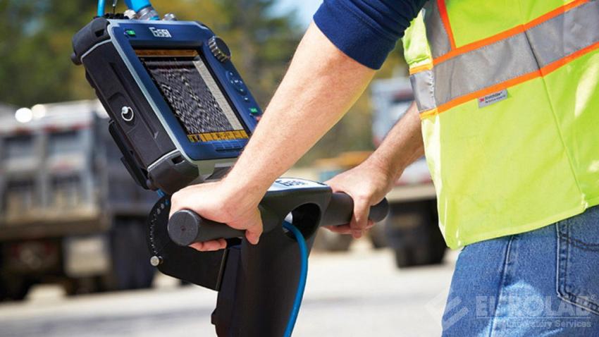
Ground-penetrating radar uses electromagnetic pulses to investigate the subsurface. A transmitting antenna sends short bursts of energy into the ground, and a receiving antenna records the signals reflected by buried objects and material boundaries.
When radar waves encounter a pipe, the contrast between the pipe and surrounding soil may produce a detectable response. The system records these reflections and displays them as radar profiles, allowing an operator to examine potential targets.
The strength and shape of a reflection can provide clues about the location and characteristics of a buried feature. By scanning along planned paths, operators can trace patterns that may indicate the alignment of a water pipe.
GPR does not identify every buried pipe automatically. A radar response may represent a water line, another utility, a geological boundary, or an unrelated object. Interpretation requires an understanding of the site and the limitations of the technology.
Locating Plastic and Non-Metallic Water Pipes
One of the most useful applications of GPR in utility investigations is identifying potential non-metallic infrastructure.
Plastic pipes can be challenging to trace because they do not conduct electricity in the same way as metallic pipes. If a pipe has no tracer wire or other conductive component, conventional electromagnetic locating methods may have limited ability to follow its route.
GPR approaches the problem differently. Rather than relying on electrical conductivity, it detects electromagnetic contrasts between the buried object and surrounding material. This means some plastic water pipes can produce identifiable radar responses.
However, visibility depends on several factors. Pipe diameter, burial depth, wall composition, surrounding soil, moisture, and the contrast between the pipe and its environment all influence detection.
A small plastic pipe buried deeply in wet, clay-rich soil may be difficult to identify. A larger pipe in favorable ground conditions may produce a clearer response. For this reason, survey planning should account for the expected pipe characteristics and local environment.
Applications in Water Infrastructure Projects
GPR can support a variety of projects involving water distribution and underground services.
a. Construction and Excavation Planning
Before trenching, foundation work, or road construction, contractors need to identify possible water lines within the work area. Radar surveys can help locate buried infrastructure and highlight areas where additional investigation may be necessary.
b. Water Leak Investigations
When a leak is suspected, GPR may help identify buried pipes and investigate surrounding subsurface conditions. Changes in moisture can sometimes influence radar responses, but GPR should not be treated as a standalone leak detection method. Specialized acoustic equipment, pressure testing, and other techniques may be required to confirm a leak.
c. Infrastructure Maintenance
Municipalities and facility managers need accurate information about existing water networks when planning repairs, upgrades, and replacement projects. GPR surveys can provide additional information where utility records are incomplete or where pipe locations need to be investigated.
d. Property Development
New developments often require connections to existing water infrastructure. Before excavation begins, contractors may use subsurface investigations to identify potential conflicts with existing pipes and other utilities.
Understanding the Role of Soil and Moisture
Ground conditions have a major influence on radar performance. Electromagnetic waves travel through soil at different velocities depending on the material's electrical properties.
Dry sand and some low-conductivity soils can allow radar signals to penetrate relatively deeply. Clay-rich soils and highly conductive environments can absorb or weaken radar energy, limiting the depth at which a pipe can be detected.
Moisture is another important factor. Because water changes the electrical properties of soil, it can affect signal travel time and attenuation. This can influence both the visibility of buried pipes and the accuracy of depth estimates.
These variations make it important to evaluate the site rather than assume that a particular GPR system will produce identical results in every environment.
Choosing the Right GPR Equipment
The best equipment for a water pipe investigation depends on the expected pipe depth, material, diameter, and the surrounding ground conditions.
Higher-frequency antennas generally provide better resolution for shallow targets but may have more limited penetration. Lower-frequency antennas can investigate deeper areas, although the resulting data may show less detail.
A system with multiple frequency ranges can be useful when a survey involves pipes at different depths or requires both shallow detail and deeper investigation.
Other considerations include the equipment's portability, battery life, display interface, data recording capabilities, and compatibility with positioning technology. For larger utility projects, the ability to connect radar data with GPS or mapping software can make the findings easier to organize and share.
From Detection to Accurate Water Pipe Mapping
Finding a possible water pipe is only the beginning of the investigation. The detected feature needs to be mapped in a way that helps engineers, contractors, and maintenance teams understand its location.
Operators typically collect radar profiles along a series of scanning lines. Repeated measurements can help establish the continuity and direction of a potential pipe. Crossing survey paths may provide additional evidence about its position.
Software can then be used to review the collected data, annotate potential targets, estimate depths, and create visual representations of the findings. When positioning information is available, the observations can be associated with geographic coordinates and incorporated into utility drawings.
The final documentation should explain the survey area, methods used, interpreted findings, and any limitations. Potential pipe locations should not be presented as confirmed infrastructure unless they have been verified through appropriate means.
Why Combining Locating Methods Is Important
No single detection method is suitable for every underground water pipe. GPR can provide valuable information about non-metallic and metallic targets, while electromagnetic locating can help trace conductive pipes or tracer wires.
Existing utility records, surface indicators, inspection chambers, and other site information can also support the investigation. In high-risk areas, carefully planned physical verification may be necessary before excavation proceeds.
Using complementary methods helps reduce uncertainty and gives project teams a stronger basis for deciding where and how to dig.
Conclusion
A GPR water pipe locator can help professionals investigate buried water infrastructure without immediately disturbing the ground. Its ability to detect subsurface contrasts makes it particularly useful when pipe materials, incomplete records, or congested utility corridors create challenges for conventional locating methods.
Successful results depend on suitable equipment, favorable ground conditions, careful scanning, and informed interpretation. When GPR is combined with other locating techniques and appropriate verification, it becomes a valuable tool for construction planning, water network maintenance, and safer excavation.